
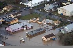
Got Flooding? What do your maps say?
To help residents and businesses to be better prepared for the risk of flooding, the Department of Coummunity and Economic Development (DCED) has launched a website containing the new Digital Flood Insurance Rate Maps established by the Federal Emergency Management Agency (FEMA). This website www.pafloodmaps.com contains a digital version of FEMA's flooplain maps which were established to designate specific areas that are special hazards or risk premium zones in order to determine whether flood insurance is required.
The site provides information to municipal officials, residents, and insurance agencies and brokers. It also alerts users to the potential risks and responsibilites associated with being located in a floodplain.
Simply log into the site, click on view flood maps, type in address and after a short wait the site will notify you whether you are located within the flood plain or not....try it yourself
For more information on Flood Insurance and reduced rates, go to FEMA Flood Site This is the official site of the National Flood Insurance Program. It offers better rates and information for homeowners who have primary structures in the floodplain.